

Canoeing the Whanganui River is considered one of the Great Walks of New Zealand. Okay, you aren’t technically walking this one, but it is considered a premier track passing through diverse and beautiful scenery of New Zealand. There are only 9 Great Walks for New Zealand, and this one is 145 km of canoeing the Whanganui River. To canoe the whole length can typically take about 5 days to complete. You can canoe a smaller section of the river if you want to take a shorter trip (2-4 days).
Casey and I had this on our list of top things we wanted to do while traveling New Zealand. We made a friend while WWOOFing who also was thinking of canoeing the Whanganui River. We stayed in contact and managed to book the trip at the same time in mid-February. (If you know backpackers, then you understand how magnificent of an accomplishment this was!)
We planned to complete the trip in 5 days, and booked our canoes through Whanganui River Canoes (WRC). We would put in at Taumarunui/Cherry Grove (this isn’t actually the start of the Whanganui Park but leads into it) and finish at Pipiriki. We camped the night before at the WRC campsite. This is where we met up with our friend Max, who also brought along his Aussie friend, Rylan. Casey and I were given four barrels by WRC, two large and two small. We all discussed our packing plans while attempting to tetris all our camping supplies, food, and clothes into the barrels to be ready for the early departure the next morning.
Eventually we managed to secure the lids on the barrels and decided to find a pub in town to chat and drink beer. We were looking forward to our 5 day canoe trip together.
We started our trip on the 9th of February and came out on the 15th. Peak summertime for the southern hemisphere. The shuttle loaded up our canoes and barrels. There were two other groups that were canoeing the river, but were shorter trips than ours. They were dropped off first because of this. While the driver would make stops, he would give us details about each section of the river so we could be prepared for it during our trip. We also received very detailed maps about the river and rapids.
Before we were able to get started, we were given thorough instructions about paddling our canoes. Especially what techniques to use when going through rapids. We were very thankful for the instructions, as we had never had any ‘training’ – just experience gained on family canoe trips.
Day 1: Taumarunui/Cherry Grove to Ohinepane
Starting at Cherry grove, we were just outside the Whanganui Forest. There were quite a few rapids to navigate. Casey and myself in one canoe, Max and Rylan in the other. We took turns going first through the rapids, seeing who could navigate better. We had a lot of fun! We only had three hours of canoeing, which was good since we were dropped off last by WRC.

The river at first navigated through farmland, but soon began to change to rolling hills.

Along the river we saw a sign for coffee. This took us by surprise, and we all decided to stop. Lauren’s Lavender Farm is right off the river. It offers a variety of lavender infused products, and has a cafe! There are some steps to get up the hill, then you arrive out into the lavender fields.
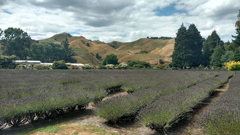
We went up to the barn shaped building and enjoyed a hot beverage, along with some scones and muffins. We were soon back on the river and feeling really good about our trip so far.

We arrived at Ohinepane in the late afternoon. We made camp and then took some time to swim in the river. Later, after dinner, we drank some port and Rylan taught us a new card game “Up the River, Down the River.” We thought it was appropriate for our journey together.

Day 2: Ohinepane to Whakahoro
The days trip was much longer than the first. A full day of canoeing. The river was widening and we entered into the Whanganui National Forest. We still enjoyed competing with our friends while navigating through rapids. Mostly we paddled in silence taking in the sounds and scenery.
Casey and I were reviewing the map and looking for anything special to stop and see. We noticed a very small side river and decided paddle a little ways up it. It brought us to a small pool and waterfall.

Our campsite for the night would be at Whakahoro. There is a small side river that you must paddle up. It’s a short distance, and the water here is not too deep or strong.
After a long day of paddling, and wanting nothing but to cool off in the river water, we were surprised by an up-hill challenge (literally). We had a huge hill to hike to get to the campsite. We carried up our barrels with all our camping supplies and quickly setup our campsite. Then made the journey back down to the side river to enjoy a cool swim before making dinner.

The view of the river from the campsite was beautiful! It made the uphill hike worth the exercise! That evening we drank the last of the port and played more cards. The night sky was clear and we all sat for a while admiring the stars.
I must mention that the campsite was also part of some farmland. During the night/early morning a herd of sheep came through the lot. It woke us all up, but they didn’t bother our tent much. The morning light on our camp was beautiful and I wish I could have better captured the fog and light in the hills.

Day 3: Whakahoro to John Coull
This day was about the same distance as the last, but it felt slower since the river was becoming wider and there were less rapids to push us along. It was a lot more paddling! The hills became higher and towered around us. The scenery became breathtaking.

It was nice when we came across a rapid after we had been paddling so slowly down the wide river. Casey and I enjoyed the challenges of the rapids. Sometimes having to avoid large boulders or trees the river had captured. Some rapids were so strong they would jolt us up and down. I could not help but let a roar of laughter out as we were thrashed around while paddling through the rapids!
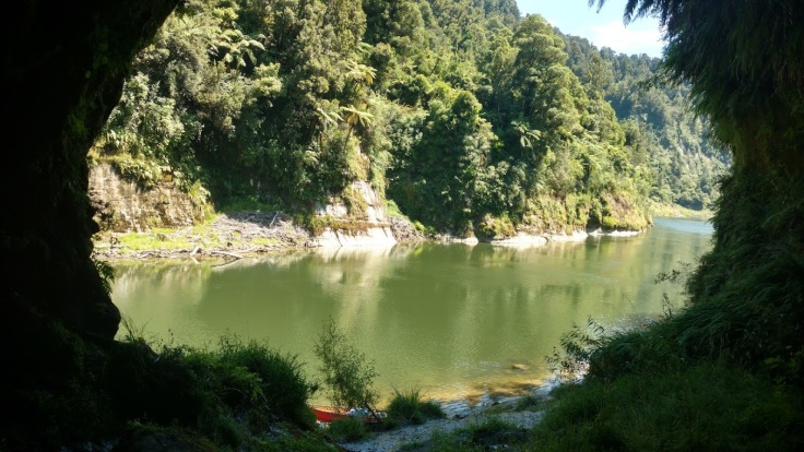
Eventually the river came to an open cliff overhang: Tamatea’s cave. We did not realize the cave was wāhi tapu (a sacred place), and unknowingly went inside. Though I suspect were were not the first ones to do so, as inside the cave are several markings.
We were soon back on the river and had a smooth day of canoeing. We eventually made it to our campsite: John Coull. This was my favorite campsite from the whole trip! I unfortunately took no pictures of it. The hut was really nice, and the campsite had multiple levels cut into the hillside to provide a flat place to setup a tent.
Max and Rylan had booked the hut to stay in, so Casey and I setup our campsite and made friends with our neighbors. Two local kiwis. We stayed up a little late chatting with them and playing cards, but it was fun!
Day 4: John Coull to Tīeke Kāinga
The next morning there was a light rain falling. We quickly took down the tent to avoid too much water getting in. As we paddled along the river we were still getting drizzled on for some of the morning. This made the river beautiful, as there was a fog on the river and mist in the hills.

This day the distance canoeing was not as far as the last two, but we stopped for a decent hike to the Bridge to Nowhere. It is about 45 minutes walking the trail from the Mangapurua Landing. When you are on the river you will see signs for it, but be prepared to paddle hard to get over there if you are a little late noticing it.
The Bridge to Nowhere was built in the mid-1930’s. It was thought there was going to be a settlement built for returning soldiers. The bridge was built first, but they soon realized the land was not suitable and the project was abandoned. The bridge still stands today, solitary and looking out of place among the hills and forest.


Standing on the bridge we looked down at the river below and could occasionally spot some eels swimming around.
After viewing the bridge we hiked back to our canoes. We were seeing more jetboats on the river, touting tourist around. There were many tourists getting dropped off to see the Bridge to Nowhere.
The jetboats sometimes surprised me, since the river became narrow and shallow at times. But the boats were always making in through!

We had a full day of canoeing, but the break to hike and see the bridge was a great rest of our arms and bums! Sitting in a canoe for that long can make you tired of sitting! We usually tried to take breaks to get out and stretch, swim, or eat a meal.
Our campsite for the night was Tīeke Kāinga. Here visitors can view the intricately-carved pou whenua (carved timber pole) and learn about the history of Tīeke and the tikanga (protocol) of the marae. We were unlucky that there were no iwi present to greet us at the time of our visit. I would have liked the experience of meeting and learning about the Maori culture.
After we setup our tents, we decided to try our luck getting across the river to the pub. It was a bit of a challenge getting across. Max, Rylan, and eventually our new kiwi friends joined us for a beer on the balcony that overlooked the river. We discussed what it might be like to farm the land around the river. I happily pet the dogs that came to visit us.


The sun began to set and we made our way back across the river to our campsite. Max and Rylan had decided to not stay in the hut, and were camping close to us again.
Day 5: Tīeke Kāinga to Pipiriki
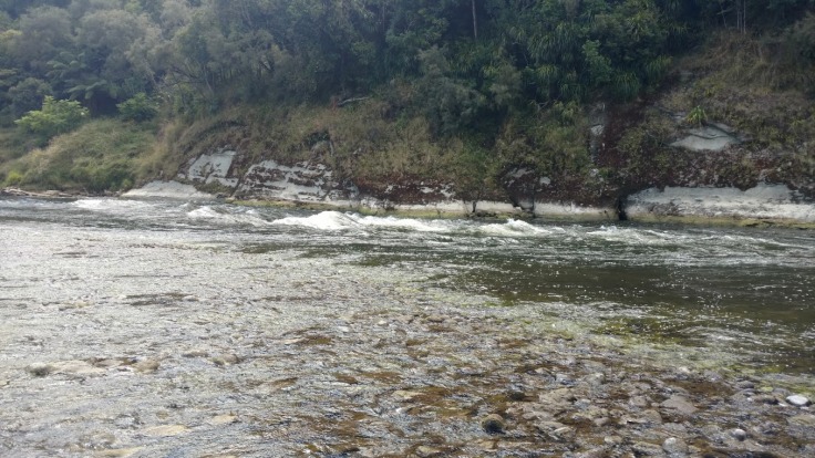
We knew we had a shorter day of paddling, and so we slept in a bit. We were actually the last ones to leave the campsite that day. The river moved slow for most of the morning. The river continued to wind through the forest and high hills. We had been told that some of the hardest rapids would be at the end of our journey.
It was after Ngaporo the river bends in an “S” shape, and the rapids pick up. This is where the day got more interesting!
The first hard rapid we came across we decided to park our canoes before we crossed it. We watched some others go through, struggle, and mostly make it. There was a large boulder in the middle, which had a canoe wrapped around it at the bottom. The water pressure here was going to be intense. Max and Rylan made it through pretty well, but we did not manage so successfully. We actually breached the bolder head-on, but at least we did not tip or take on any water.
We took our time the rest of the day canoeing, casually making stops. We really enjoyed our final day along the Whanganui River. The last big rapid soon came, and WOW was it a hard one! Not one person we saw go through came out above the water.
Casey and I went through and were laughing the whole way. The rapids lift and drop the canoe so much! Then, there is a huge drop – which is what causes most of everyone to take on way too much water! As we came out of the rapid, still paddling, our canoe was completely under the water. We managed to get ourselves to the rock bank and had to tip our canoe.
We saw many other people empty the water from their canoes and go for another attempt through the rapid. We enjoyed watching our friends and others make the second/third/or even fourth attempt to tame the beast (with no luck I would add).
There was one last rapid before we reached Pipiriki, but it was tame compared to the last big one. We eventually made it to the boat-ramp, where we saw other people waiting to be picked up. Our shuttle soon arrived and the driver gave us some nice refreshments to enjoy during the trip back to WRC. We had a nice view of ‘Mt. Doom’ or commonly known as Mt Ngauruhoe during the drive.

We had a blast navigating the Whanganui river! The trip was a good test of our strength. We had many laughs with friends, conquering the challenges the river gave us, and made some awesome memories to cherish!
Have you canoed the Whanganui River? Share your experience below.
If you enjoyed this post please Like, Comment, and Share.
Thanks for reading!

Leave a comment